搜索结果: 1-15 共查到“City”相关记录822条 . 查询时间(0.14 秒)
湖南“马栏山City walk福利季”开启
湖南 马栏山 City walk
2024/3/18
日前,由湖南省文化和旅游厅主办的“马栏山City walk”宣传推介会在长沙世界之窗举办。会上,主办方启动“马栏山City walk福利季”,并宣布向社会发放价值380万元的文旅消费券。消费券覆盖景区门票、文化体验、特色餐饮等内容。
Estimating Carbon Sequestration Potential of Forest and Its Influencing Factors at Fine Spatial-Scales: A Case Study of Lushan City in Southern China
fine-scalebiomass expansion factortree growth equationcarbon sequestration potentialsite characteristics
2023/11/20
Accurate prediction of forest carbon sequestration potential requires a comprehensive understanding of tree growth relationships. However, the studies for estimating carbon sequestration potential con...
Academy of Mathematics and Systems Science, CAS Colloquia & Seminars:International trade and Covid-19: City-level evidence from China's lockdown policy
国际贸易 新冠肺炎 中国封锁政策 城市证据
2023/5/16
Researchers used the City of Pittsburgh to create a model built upon the design, materials and purpose of commercial buildings to estimate their energy usage and emissions.

Weather surveillance radar data shows 45 million insects taking flight over brightly lit city(图)
Weather surveillance radar data 45 million insects flight lit city
2021/4/16
The expansion of artificial night lights globally has had important impacts on animal behavior and health. A new study led by researchers at the University of Oklahoma on the effects of brig...

Researchers set to take to the air above the Arctic and New York City(图)
air above Arctic New York City
2020/10/10
Atmospheric scientists are embarking on two new research projects supported by the U.S. National Science Foundation that involve using sophisticated planes to understand the atmospheric chemistry and ...

中国矿业大学计算机科学与技术学院团队在CVPR Workshop 2020 AI CITY竞赛中荣获全球第五(图)
中国矿业大学计算机科学与技术学院 CVPR Workshop 2020 AI CITY 全球第五
2020/7/2
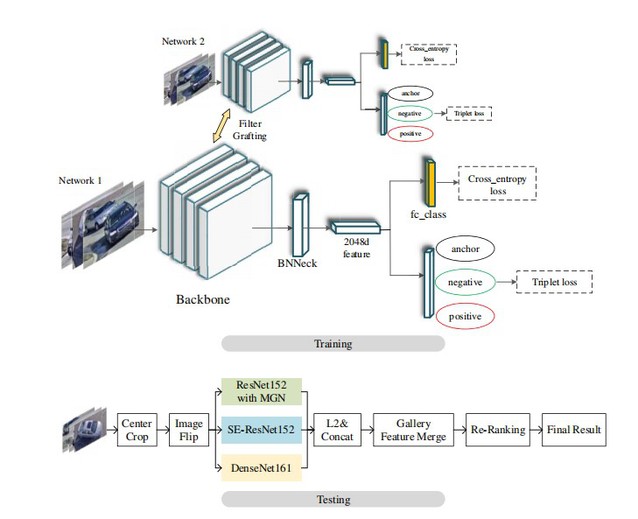
近日,由IEEE国际计算机视觉与模式识别会议(CVPR)Workshop主办的“智能交通视频分析界的ImageNet竞赛”——英伟达智慧城市挑战赛(AI CITY CHALLENGE 2020)落下帷幕。我校计算机学院周勇教授、姚睿副教授和赵佳琦副教授指导,由硕士生高存远等组成的竞赛团队BestImage获得赛道二:城市级规模的多摄像头下的车辆重识别竞赛(City-Scale Multi-Came...

Data scientists map the supply chains of every U.S. city(图)
Data scientists supply chains U.S. city
2019/10/30
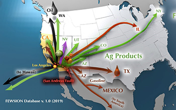
No matter where you live in the United States, some food in your kitchen probably started its life in California's agricultural fields.How do you know? Vegetables, like every other product, follow a s...

City trees can offset neighborhood heat islands(图)
City trees offset neighborhood heat islands
2019/11/22
The concept of heat islands -- densely built-up urban areas that are hotter than the rural and semi-rural landscapes around them -- has been extensively studied and is widely accepted.Now a new study ...
INTEGRATION AND COMPARISON OF CLOSE-RANGE SFM METHODOLOGIES FOR THE ANALYSIS AND THE DEVELOPMENT OF THE HISTORICAL CITY CENTER OF BETHLEHEM
UAVs acquisition Structure from Motion Bethlehem historical Cultural Heritage reliable tests
2019/3/4
The present paper illustrates a part of the methodological process of image-based acquisition developed for the documentation of the historical city center of Bethlehem, in the Middle East territory. ...
KNOWLEDGE-BASED FRAMEWORK FOR AUTOMATIC SEMANTISATION AND RECONSTRUCTION OF MILITARY ARCHITECTURE ON CITY-SCALE MODELS
city-scale model knowledge-based modelling architectural heritage
2019/3/2
The scale models of fortified towns belonging to the Plans-Reliefs collection are exceptional witnesses of the formation of the French territory. The aim of the URBANIA project is the valorisation and...
1D-2D MODELING OF URBAN FLOODS AND RISK MAP GENERATION FOR THE PART OF HYDERABAD CITY
Stormwater Urban Flood Modeling Zone XIII SWMM PCSWMM
2019/2/27
Space for water is now becoming guiding principle of urban planning because urban flooding is the major problem facing by most of the cities in India. Urban development in developing countries like In...
A 3D CAMPUS APPLICATION BASED ON CITY MODELS AND WEBGL
3D GIS 3D Campus Visualization WebGL City Modeling
2019/2/27
In parallel with the technological developments, the conventional ways of mapping and the presentation of the geospatial data have changed significantly. 3D city models including the digital terrain m...
SEMANTIC MODELING OF UTILITY NETWORKS IMPLEMENTATION OF USE CASES FOR DEHRADUN CITY
OGC CityGML data model Utility Network ADE data storage utility infrastructure use cases
2019/2/27
The current on-going boom in the field of Building Information Modeling (BIM) and 3D GIS is widely being explored for vast urban related applications, analyses and simulations. Large amount of 3D city...
DENDROGRAM CLUSTERING FOR 3D DATA ANALYTICS IN SMART CITY
Smart City Dendrogram Clustering 3D Spatial Database 3D GIS Data Analytics Data Structure
2018/11/9
Smart city is a connection of physical and social infrastructure together with the information technology to leverage the collective intelligence of the city. Cities will build huge data centres. Thes...


